
চিত্ৰ:Oceania ISO 3166-1.svg

Size of this PNG preview of this SVG file: 780 × 500 পিক্সেল. আন ৰিজ'লিউশ্যনসমূহ: 320 × 205 পিক্সেল | 640 × 410 পিক্সেল | 1,024 × 656 পিক্সেল | 1,280 × 821 পিক্সেল | 2,560 × 1,641 পিক্সেল।
মূল ফাইল (SVG ফাইল, সাধাৰণতঃ 780 × 500 পিক্সেল, ফাইল মাত্ৰা: 146 KB)
| এই ফাইলটো ৱিকিমিডিয়া কমন্সৰ পৰা আমদানি কৰা হৈছে। ফাইল বিৱৰণ পৃষ্ঠাৰ সবিশেষ তথ্য তলত উল্লেখ কৰা হ’ল ।
|
সাৰাংশ
| বিৱৰণ |
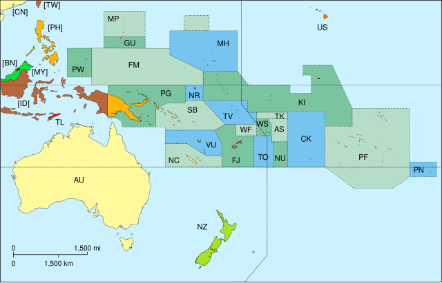
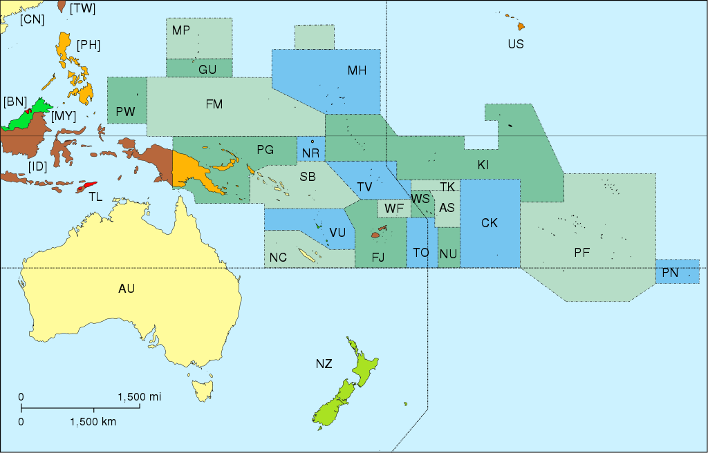
Map of Oceania, with ISO 3166-1 pt · en country and territory code. SVG format. Map legend in Portuguese and English, with name of sovereign state given in parenthesis, where applicable:
On map, but part of Asia:
|
| তাৰিখ | |
| উৎস | নিজা কাৰ্য |
| লেখক | Júlio Reis |
| অন্যান্য সংস্কৰণ |
|


অনুজ্ঞাপত্ৰ
এই ফাইলটো ক্ৰিয়েটিভ কমন্স এট্ৰিবইউচন-চেয়াৰ এলাইক ৩.০ আন্প'ৰ্টেড অনুজ্ঞাপত্ৰৰ অধীনত।
- আপুনি স্বাধীনভাৱে:
- বিতৰণ কৰিব পাৰে – কামটো নকল (কপি), বিতৰণ আৰু প্ৰেৰণ কৰিবলৈ
- পুনৰ্মিশ্ৰণ কৰিবলৈ – কামটো অভিযোজন কৰিবলৈ
- তলত উল্লেখ কৰা চৰ্ত্তসমূহৰ ভিত্তিত:
- স্বীকৃতিপ্ৰদান – আপুনি প্ৰয়োজনীয় স্বীকৃতি দিয়াৰ লগতে অনুজ্ঞাপত্ৰলৈ লিংক আৰু কোনো সালসলনিৰ ইংগিত দিব লাগিব। আপুনি এয়া উপযুক্ত ধৰণেৰে দিব পাৰে, মাত্ৰ অনুজ্ঞাপত্ৰধাৰীয়ে আপোনাক বা আপোনাৰ কামক মঞ্জুৰী জনোৱাৰ দৰে নিলিখিব।
- একে ধৰণে চেয়াৰ কৰক – যদি আপুনি এই কামটো পৰিবৰ্তন, ৰূপান্তৰ বা এই কামটোৰ উপৰত ভিত্তি কৰি নতুন সৃষ্টিকৰ্ম তৈয়াৰ কৰে, আপুনি শেষৰ কৰ্মটো পূৰ্বৰ কৰ্মটোৰ সৈতে একে বা একেধৰণৰ অনুজ্ঞাপত্ৰৰ আওতাত বিতৰণ কৰিব পাৰে।
derivative works
Derivative works of this file: Oceania blank.svg
ফাইলৰ ইতিবৃত্ত
ফাইলৰ আগৰ অৱস্থা চাবলৈ সেই তাৰিখ/সময়ত ক্লিক কৰক।
| তাৰিখ/সময় | ক্ষুদ্ৰ প্ৰতিকৃতি | আকাৰ | সদস্য | মন্তব্য | |
|---|---|---|---|---|---|
| বৰ্তমান | 17:45, 7 November 2015 | | 780 × 500 (146 KB) | BurritoBazooka | getting rid of transparent border around map |
| 16:50, 25 March 2014 |  | 800 × 520 (145 KB) | Knyaz-1988 | New version | |
| 16:49, 25 March 2014 |  | 800 × 520 (162 KB) | Knyaz-1988 | Reverted to version as of 04:23, 21 December 2007 | |
| 04:24, 21 December 2007 |  | 800 × 520 (162 KB) | ButterStick | ||
| 04:23, 21 December 2007 |  | 800 × 520 (162 KB) | ButterStick | ||
| 04:21, 21 December 2007 |  | 800 × 520 (162 KB) | ButterStick | Code optimization | |
| 13:35, 30 May 2006 |  | 800 × 520 (238 KB) | Tintazul | {{Tintazul| |Description=Map of Oceania, with ISO 3166-1 <sup>pt · en</sup> country and territory code. SVG format. Map legend in Portuguese and English, with name of sovereign state given in parenthesis, where appl |
ফাইল ব্যৱহাৰ
তলত দিয়া পৃষ্ঠাটোৱে এই ফাইলটো ব্যৱহাৰ কৰে:
ফাইলৰ গোলকীয় ব্যৱহাৰ
তলত দিয়া আন ৱিকিসমূহে এই ফাইলটো ব্যৱহাৰ কৰে:
- ace.wikipedia.org-ৰ ব্যৱহাৰ
- ar.wikipedia.org-ৰ ব্যৱহাৰ
- bat-smg.wikipedia.org-ৰ ব্যৱহাৰ
- cs.wikipedia.org-ৰ ব্যৱহাৰ
- de.wikipedia.org-ৰ ব্যৱহাৰ
- de.wiktionary.org-ৰ ব্যৱহাৰ
- diq.wikipedia.org-ৰ ব্যৱহাৰ
- en.wikipedia.org-ৰ ব্যৱহাৰ
- es.wikipedia.org-ৰ ব্যৱহাৰ
- et.wikipedia.org-ৰ ব্যৱহাৰ
- fa.wikipedia.org-ৰ ব্যৱহাৰ
- gd.wikipedia.org-ৰ ব্যৱহাৰ
- gl.wikipedia.org-ৰ ব্যৱহাৰ
- gl.wikiquote.org-ৰ ব্যৱহাৰ
- ia.wikipedia.org-ৰ ব্যৱহাৰ
- incubator.wikimedia.org-ৰ ব্যৱহাৰ
এই ফাইলটোৰ অধিক গোলকীয় ব্যৱহাৰ চাওক।